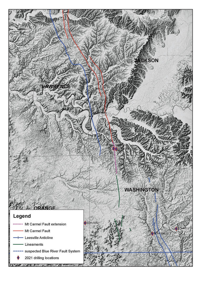
This map shows the known location of the Mount Carmel Fault (red solid line), the newly discovered extension of that fault (red dashed line) and the location of a probable new fault system (blue dashed line).
Don Tripp | Indiana Geological and Water Survey
In the course of doing their normal work, two geologists from the Indiana Geological and Water Survey believe they’ve found a fault and a fault extension in the southern Indiana landscape that haven’t been mapped before.
In November, Don Tripp and Sarah Burgess were drilling to collect cores — long, cylindrical samples of rock and sediment layers — south of the known Mount Carmel Fault, east of Paoli off of State Road 56, when they hit a line of sinkholes.
The Mount Carmel Fault extends 50 miles north-northwest across Washington, Jackson, Lawrence and Monroe counties.
Tripp and Burgess moved the drilling operation downhill and hit a type of rock they didn’t expect to see at the depth the drill had reached as well as fractures and voids in the core.
Burgess said this was evidence of an anticlinal structure, an arch-shaped trap below the surface that could contain, gas, oil or water. Those structures are formed by pressure squeezing rock layers into folds.
More data came from studying rock types and elevations at Mitchell Plateau outcrops in Washington County.
Before going out to a site, Tripp runs through some trigonometry calculations so he can anticipate what type of rock will appear at specific points. His predictions are usually accurate to within about 5 feet, but if they’re off by 30 or 40 feet, there could be “something going on,” like a fault, he said.
While collecting field data in mid-January, Tripp and Burgess noticed a drastic difference among their data points in the elevations where particular rock layers met. That displacement is called offset. Among these points — south of Salem near the Blue River — they were seeing 70 to 100 feet of offset.
“So clearly, it has been shifted,” Burgess said.
Based on their data, they believe the Mount Carmel Fault extends 6 to 20 miles further south of where it was previously mapped in Washington County and that a different but probably related north-south fault exists about 10 miles to the east, southeast of Salem. So far, they’ve been calling the new fault the Blue River Fault.
When the weather warms up, they’d like to take a boat out on the Blue River to find rock outcrops and gather clues like fault gouges from the more visible rock layers. They also could conduct seismic reflection or refraction using their drill holes to produce images of what’s going on in the deep subsurface.
Burgess, an avid caver, has done some exploring of the area underground at Cave River Valley on the Mitchell Plateau north of Campbellsburg. From that vantage point, one can see evidence of faulting in slickensides — sections of rock that have been rubbed smooth because of shifting.
Burgess believes the chemical makeup of rocks in this area may be one reason why these faults haven’t been mapped before. The Mitchell Plateau is made up of carbonates, which dissolve in acidic groundwater and can erode to the point where they can look flat even though they’re different kinds of rock, she said.
“So there’s not a good surface expression of the fault, even though it’s a very big (fault) system and it’s unlikely to just stop (at the point where it was previously mapped to stop),” she said.
Though faults are most broadly associated with earthquake danger, Burgess said these faults are not in a very active zone, so there’s “not a lot of concern” for damaging earthquakes in this region.
What faults can point to are trapped resources, such as springs, oil and natural gas. IGWS staff members already had mapped several perennial springs in this region for a separate project — another clue that faults may be present — and Burgess noted several exploratory oil wells had been placed in this region.
“It’s less of an earthquake hazard and more of part of a predictive feature of some natural resources,” she said about the new fault data.
The Indiana Geological and Water Survey is a research institute of Indiana University and has a mission to provide geologic information and counsel that contribute to the wise stewardship of the energy, mineral and water resources of the state.