
Lucas

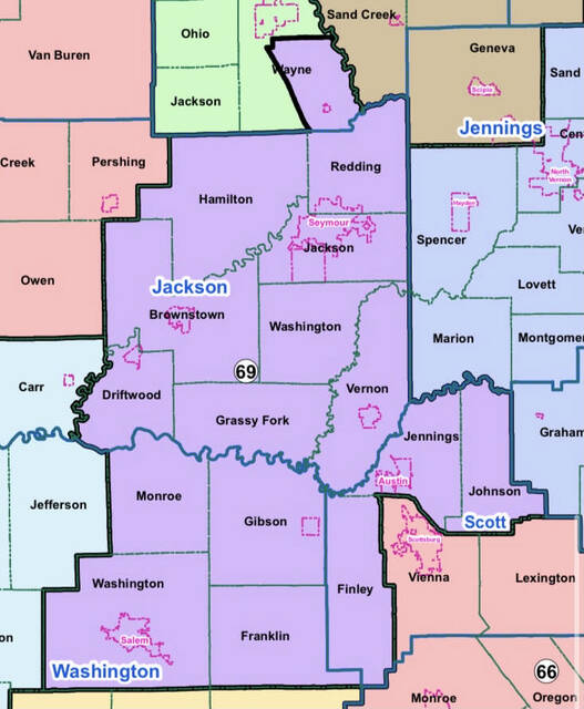
Indiana House District 69
Gov. Eric Holcomb put his stamp of approval on Monday to the Republican redrawing of the state’s congressional and legislative districts that will be used in elections for the next decade.
Jackson County will continue to be served by three House districts, but just one Senate district.
The largest is House District 69, represented by Rep. Jim Lucas.
Lucas said his district dropped all of Jennings and Jefferson counties but added two townships in Jackson County and some townships in Scott and Washington counties. He also went from representing Elizabethtown in Bartholomew County to Jonesville, the Austin area in Scott County and the Salem area in Washington County.
Holcomb said redistricting was done in “an orderly and transparent fashion,” and Lucas said he agreed.
“It’s a big change when you look at it on the map, but I think it’s just as conservative, if not more conservative, than the old district was,” Lucas said.
When redrawing districts, Lucas said population data was taken into consideration based on 2020 Census results.
Around 67,000 Hoosiers are in each house district, and about 134,000 people live in each Senate district.
“These are great districts for everybody, not just southern Indiana or District 69, but throughout the state,” he said.
In 2022, the Seymour Republican will represent Brownstown, Driftwood, Grassy Fork, Hamilton, Jackson, Redding, Vernon and Washington townships in Jackson County.
The district also will include Wayne Township in Bartholomew County, Jennings and Johnson Townships in Scott County and Finley, Franklin, Gibson, Monroe and Washington townships in Washington County.
Also in 2022, Owen, Pershing, and Salt Creek will become part of House District 62, which includes all of Brown County and parts of Monroe County including Bloomington. That seat is presently held by Republican Jeff Ellington of Bloomington.
Carr Township will be part of House District 65. Bedford Republican Chris May presently represents that district, which also includes all of Lawrence County and portions of Orange and Washington counties.
Senate District 44, currently represented by Bedford Republican Eric Koch, will include all of Jackson, Brown, Lawrence and Orange counties and a slice of southeastern Monroe County in 2022. Vernon Township in Jackson County has been in Senate District 45 since the 2010 Census.
Holcomb’s signature was the final step in the redistricting for the state’s nine congressional seats and 150 seats in the state Legislature that were drawn by Republican leaders behind closed doors and adopted Friday in the Legislature without any support from Democrats, according to the Associated Press.
The maps faced intense criticism as giving Republicans an excessive election advantage and diluting the influence of minority and urban voters in favor of white voters living in rural areas. That came after the 2020 census found that the state’s white and rural populations both were shrinking.
Holcomb said in a statement he believed that legislators completed the redistricting work in “an orderly and transparent way.”
Political analysts say the new maps that will be used through the 2030 elections protect the Republican dominance that has boosted them to a 7-2 majority of Indiana’s U.S. House seats and commanding majorities in the state Legislature. Critics argued the process was rushed as Republicans pushed for the Oct. 1 final votes just 17 days after the release of their congressional and Indiana House maps.
The House map increases the number of counties that are wholly contained within one House district from 26 to 32. There are 22 fewer township splits where a single township is represented by multiple House districts. The House map includes a less than 1% deviation from the ideal population of 67,855 for each district.
The Senate map increases the number of whole counties contained in one Senate district from 49 to 65, keeps 96% of all townships whole and keeps 92% of all cities and towns whole.
The Congressional map keeps 84 of Indiana’s 92 counties whole, and includes a near equal deviation, one or fewer persons, from the ideal population of 753,948.
According to a news release from the Senate Republican Caucus, legislators hosted public meetings in Indiana’s nine congressional districts to gather feedback from the public on the redistricting process in early August.
The Senate and House elections committees also held a total of three public hearings on HEA 1581, which contains the maps, as the legislative process played out in September. Archived videos of the meetings are available at iga.in.gov/redistricting. In total, more than 18 hours of public discussions were held on the maps and legislators heard from more than 200 members of the public.
The General Assembly also launched an online portal that allowed Hoosiers to draw and submit their proposed new district boundaries for the U.S. House of Representatives, the Indiana House of Representatives and the Indiana Senate. The web portal contained all the same census and election data lawmakers had access to as they drew the new Statehouse and congressional district maps.