Straight-line winds vs. a tornado. Watches vs. warnings.
Do you know the difference? Whether the answer is yes or no, Severe Weather Preparedness Week is a great time to refresh your knowledge or learn some new information.
Indiana Gov. Eric Holcomb proclaimed that week for March 13 to 19 in the state.
At 10:15 a.m. today, the National Weather Service in conjunction with the Indiana State Police, Indiana Department of Homeland Security, Indiana Department of Education, Indiana Broadcasters Association, American Red Cross and Amateur Radio Operators will conduct a statewide test of communication systems.
While the drill will be sent using live tornado warning coding, it is only a test.


“This test will initiate out of the National Weather Service just like the real event,” said Duane Davis, director of Jackson County Emergency Management Agency.
“It will come into our dispatch center, and they will set off alarms.”
Davis said there are seven tornado sirens in Seymour city limits and five others around the county, and people should have multiple ways of receiving alerts, whether through their cellphone, notifications or a weather alert radio.
Participating in this test is one of the ways the local EMA office will celebrate Severe Weather Preparedness Week.
Davis said a lot of preparedness information will be shared on the agency’s Facebook page, and EMA also hosted a SKYWARN weather spotter training class this past Thursday night.
The National Weather Service’s goal this week is to better educate people about the hazards of severe thunderstorms and tornadoes and help everyone be prepared when severe weather occurs.
A watch is issued when hazardous weather may occur. People should watch for information and review their safety plans.
A warning is issued when a weather hazard is imminent or reported and requires immediate action to protect life and property.
A thunderstorm is classified as severe if it produces a tornado, hail 1 inch or more in diameter or winds of 58 mph or higher.
“Watch is potential, and if it has potential, you need to be on your guard, be prepared,” Davis said. “Warning is there’s a high probability of a significant event, whether it’s straight-line winds or a tornado. If you get a warning, then you need to seek shelter in a safe place.”
If a person is in a home or small building, go to the basement or an interior room on the lowest floor, such as a closet or bathroom. Wrap yourself in overcoats or blankets to protect yourself.
In schools, hospitals, factories or shopping centers, go to the interior areas on the lowest floor, stay away from glass and very large rooms and follow the instructions of the facility’s safety officials.
If you find yourself in a car or mobile home, leave it for a substantial structure or designated tornado shelter. As a last resort, lie flat in your car or nearby ditch and use your hands to cover your head.
In 2021, Indiana saw 20 tornadoes, according to the National Weather Service. This year is the 10-year anniversary of the Henryville tornado, which is the last time a tornado-related fatality occurred in Indiana. The record number of tornadoes in a year for Indiana is 72 in 2011.
Tornadoes occur year-round but are most likely to occur from April to June. Primary hours are from 3 to 8 p.m. with a second peak from midnight to 3 a.m.
In the event of severe weather, Davis said it’s important for people to have a plan so they can take care of themselves as much as possible.
The Red Cross recommends having these items in your emergency preparedness kit: Food and water for three days (1 gallon of water per person per day), flashlights and extra batteries, a battery-powered or hand-crank radio (NOAA Weather Radio if possible), a first aid kit, medications (seven-day supply) and medical items, a multi-purpose tool, personal hygiene items, copies of personal documents, extra cash, an emergency blanket and baby and pet supplies.
On March 6, a straight-line wind event occurred in Jackson County, as significant damage was reported in Cortland and Seymour.
Davis said he found a tree down on County Road 100W. The soil was saturated, and the high wind uprooted the tree. He then worked his way to more significant damage, including outbuildings damaged, a grain bin top blown off, a large farm irrigation system overturned and trees down across a roadway.
“Most of the damage was pertained to outbuildings, barn-like structures, and the majority of the damage was created because the west side of the building had a weak spot, usually a large garage door opening,” Davis said. “Once that garage door was compromised, the wind comes in, pushes the roof up and does the damage.”
With straight-line winds, Davis said wind usually comes in from the west in an easterly motion and causes damage.
After such an event, he sends pictures and a narrative to the National Weather Service, which researches the Doppler radar weather information and reviews the assessment.
On March 7, the weather service confirmed Davis’ assessment of straight-line winds, which has estimated wind speeds of 85 to 90 mph.
“That just came out of nowhere,” he said. “They could not predict this or give any type of a high wind warning for this event.”
The Point in Seymour also was impacted by those straight-line winds.
Staff members arrived the morning of March 7 to find the roof ripped off of a section of the church. Ministries Director Jeff Lewellyn said the primary damage was over the two-story education space over the west wing of the building. Also, rain water poured through the second floor to the first floor.
Lewellyn said there was extensive water damage to ceiling tiles, insulation, walls, carpets, supplies for Point Kids Ministry and some furnishings. There was very little office equipment or computer/tech equipment damage.
While he doesn’t know the total cost of the repairs, Lewellyn said the estimate for the roof repairs alone is more than $12,000.
“It will take several weeks for restoration to be complete,” he said. “This is based on what we know now and could be affected by a better understanding of the full scope of restoration. We are currently waiting on the insurance adjuster to survey the damage. A temporary roof is in place, and a remediation company has been hired to dry out the interior spaces.”
Services have gone on as usual since the worship center had no storm damage, but Lewellyn said Point Kids will be relocated to the family center and unaffected classrooms on the east side of the building.
Fortunately, with the recent event, no injuries were reported.
“That’s the best-case scenario. Everything else can be fixed,” Davis said. “People have to understand wind like that is a significant force of Mother Nature. A lot of people can’t fathom wind being that strong, but when you get into a building, that gush of wind, all of that energy has to go somewhere. Where are the weak points? Up. Damage is damage, whether a tornado or straight-line winds.”
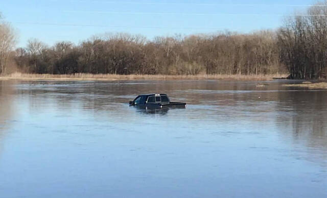
This week, Hoosiers also are reminded to be aware of the dangers of flooding.
Indiana suffered two flood fatalities in 2021, according to the National Weather Service. The majority of flood deaths are preventable and occur as a result of people driving into floodwaters.
The weather service’s Hydrologic Outlook alerts the public when flood-producing rainfall is expected in 36 to 72 hours. During February and March, this product also contains information on the potential for flooding from the spring snow melt.
A flood or flash flood watch is issued when conditions are favorable for flooding or flash flooding to develop. A warning is issued when rapid flooding is imminent. Flash floods quickly develop within six hours of a heavy rainfall event.
Flood warnings are issued for river floods or for widespread flooding across a county. River flooding mostly occurs with longer periods of rain that result in slower rises in floodwaters and a prolonged flood event.
With the East Fork White River going through Jackson County and the Muscatatuck River going along the southern border, Davis said it’s important for people to pay attention to flooding potential.
“Pay attention to the river gauges,” he said. “When the White River gets to 19 feet, have that plan of where do you go. Don’t wait and then have to call people to come get you.”
Motorists also should avoid driving through floodwaters because the road may be washed out. Remember “Turn around, don’t drown.”
“You put yourself in danger. You put rescuers in danger,” Davis said.